Wandkaarten - Engeland
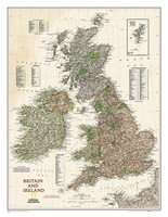 Wandkaart Groot Brittannië en Ierland antiek, 60 x 76 cm | National Geographic
This map of Britain and Ireland shows country boundaries, thousands of place names, major roadways, airports, bodies of water, and more. Rich earth-toned colors, astounding detail and boardroom quality make …
★★★★★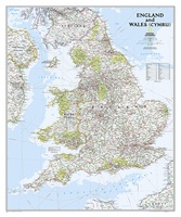 Wandkaart Engeland en Wales, 76 x 92 cm | National Geographic
This classic-style map of England and Wales shows political boundaries, major highways and roads, cities and towns, airports, and other geographic details. Thousands of place-names and exact borders are carefully …
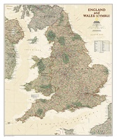 Wandkaart Engeland en Wales, antiek, 76 x 91 cm | National Geographic
This earth-toned, executive-style map of England and Wales shows political boundaries, major highways and roads, cities and towns, airports, and other geographic details. Thousands of place-names and exact borders are …
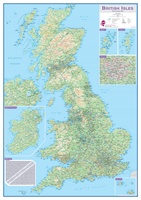
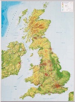 Reliëfkaart Great Britain & Ireland - Groot Brittannië & Ierland | GeoRelief
De uitgever van de kaart is de bekende Duitse uitgever GeoRelief. Deze topografische kaart van Groot Brittannië heeft een hoge kwaliteit met prachtige kleuren. De kaart bevat de namen van …
 Wandkaart Engeland - British Isles roadplanning wall map, 84 X 119 cm | Maps International
Routeplanner map from Maps International's selection of British Isles maps. Routeplanning map details: British Isles routeplanning map shows the motorways, major roads and transport hubs such as airports and …
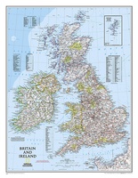 Wandkaart Britain and Ireland - Groot Brittannië en Ierland, 60 x 76 cm | National Geographic
This classic-style map of England and Wales shows political boundaries, major highways and roads, cities and towns, airports, and other geographic details. Thousands of place-names and exact borders are carefully …
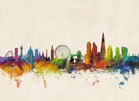 Stadskaart London City Skyline – Londen, 84 x 59 cm | Maps International
Een schitterende en kleurrijke aquarel van de skyline van Londen. Een aanwinst voor elke muur. A bright and colourful watercolour skyline of the city of London. With bold, dynamic …
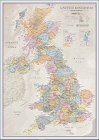 Wandkaart Classic Verenigd Koninkrijk | UK | Great Brittain | 85 x 60 cm | Maps International
Ontdek de rijke historie en schilderachtige landschappen van het Verenigd Koninkrijk met onze prachtige wandkaart, vormgegeven in een elegante klassieke stijl. Deze gedetailleerde kaart toont niet alleen de verschillende landen …
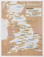 Scratch Map Bier Brouwerijen Groot-Brittannië Collect & Scratch | Maps International
Scratch Off UK Breweries Print is the perfect gift for beer lovers. This is the best way to display your travels to each brewery or if you have sampled the …
Laatste reviews

het is heel goed
★★★★★ door Marc 11 mei 2024 | Heeft dit artikel gekocht
Hallo, metrokaart van Delft gekocht. Die bestaat natuurlijk niet, maar wel heel leuk bedacht met de gekste steenkolen Engelse termen als haltes. Hilarisch. Ik hen …
★★★★★ door Nellie 10 mei 2024 | Heeft dit artikel gekocht
We hebben het boekje alleen gebruikt om wandelingen uit te halen. I.v.m. kleine kinderen hebben we vooral de 'short walks for motorists' gelopen, die echter …
★★★★★ door Jochem 10 mei 2024 | Heeft dit artikel gekocht
Prima. Wel erg gefocust op jonge mensen die geïnteresseerd zouden zijn in hippe winkeltjes en cafeetjes.
★★★★★ door Miquel 10 mei 2024 | Heeft dit artikel gekocht